Sea level has risen even though it appears Sydney Harbour has not changed in 140 years
We analyze a post from Telegram that claims that sea level at Sydney Harbour hasn’t changed over the past 140 years
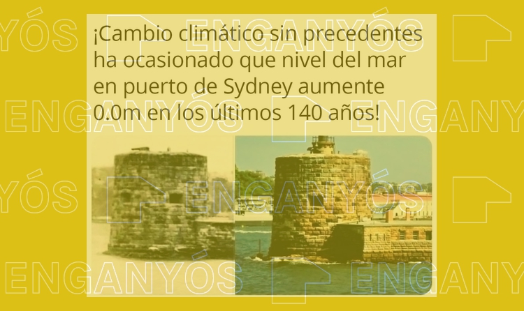
A post being shared on Telegram claims that “climate change has caused sea level at Sydney Harbour to rise approximately 0.0 cm over the past 140 years”. The post includes two images that show the same building in the middle of the sea in the Australian city. This is a MISLEADING statement: Yes, both images are real and they were taken approximately 140 years apart from one another. However, it does not show that the sea level has not risen. The building visible in the image has recorded a sea-level rise of 0.79 mm every year.
Unprecedented climate change has caused sea level at Sydney Harbour to rise approximately 0.0 cm over the past 140 years!
The post has been circulating on social networks in various languages since at least October 2018, according to what Verificat could confirm by way of a Tineye reverse image search. The text includes two photos of Fort Denison, a building located in Sydney Harbour, which were purportedly taken 140 years apart from one another, although Verificat was unable to confirm the accuracy of this information. The first image, in black and white, can be dated to the 1880s, according to Wikipedia, and cites the National Archives of Australia as the original source.
At the time this information was published, however, the Oceanian institute was unable to assure Verificat of the image’s date of creation or authorship. The second photo was taken in 2018 by the photographer Richard F. Ebert.
In any case, the comparison of two images is not valid proof of changes in sea level. First of all, because the photos “are not good enough to know that the sea is at exactly the same level”, Jordi Pagès, a postdoctoral researcher in the Marine Ecology Department at the Blanes Centre of Advanced Studies (CEAB-CSIC), explains to Verificat. And, second, because the publication is an example of cherry-picking, “a tactic of harnessing an incomplete and unrepresentative set of evidence to misleadingly make a broader argument”.
Fort Denison, the building in the photos in the post, started taking measurements in 1886. From the data collected over nearly 140 years, the facility has established a rise in sea level of 0.79 millimetres per year (7.9 centimetres per century) in Sydney Harbour, which would mean there has been an increase of roughly 10 centimetres in height between the times the two photos were taken.
Tides and regular changes
“We’re talking about a change that is very difficult to perceive in the photos”, explains Marcos Portabella in conversation with Verificat. The head of the Physical and Technological Oceanography research group at the Institute of Marine Sciences (Institut de Ciènces de Mar, or ICM-CSIC) reminds us that it is very important to take natural factors into account as well: “The tidal effect could be an order of magnitude ten times greater than 20 cm”. This phenomenon (for which there is a daily forecast) can alter the sea level in Sydney by up to 2 metres and by up to 11 metres in other places along the Australian coastline.
“Depending on the time the photo was taken, it might even look like the sea level was higher a century ago than it is today”, concurs Jorge Benito, researcher in the Ocean and Littoral Sedimentary Processes research group at the ICM-CSIC, who tells Verificat that “it does not disprove a rise in sea level”.
Why is sea level rising?
Sea level is rising chiefly as a result of two factors. One factor is that glaciers and the polar ice caps are melting. As we explain here (Spanish only), between 2002 and 2020, Antarctica lost an average of 149,000 million metric tonnes of ice per year, according to NASA’s satellite data, which has contributed to the rise in sea level.
The other factor is rising ocean temperatures, which leads to water having a greater volume and thus elevates sea level. Both factors “are associated with global warming”, Benito adds.